Application Description
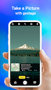
This GPS Map Camera app merges camera functionality with GPS location tracking, letting you geotagging photos as you take them. This creates a visual journal of your journeys. The app boasts a powerful mapping system for viewing your photos on a GPS map, providing a clear picture of where each shot was taken.
Beyond its core camera features, the app lets you add GPS location data to existing photos, transforming your image library into a visual travelogue. It's designed for ease of use and works flawlessly with GPS-enabled devices.
Here's a breakdown of its key benefits:
- Integrated Camera & GPS: Capture photos and instantly geotagged them with precise location data, creating a visual record of your travels.
- Versatile Photo Capture & Tracking: Use the built-in GPS camera or add location data to existing photos using the app's geotagging feature.
- Comprehensive Mapping: Easily view your photos on a map to see their locations relative to your route.
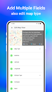
- Customizable Date & Time: Choose and add preferred date and timestamp formats to your photos.
- Personalized Photo Management: Save photos with custom names and utilize live navigation for efficient organization.
- Lightweight Alternative: A Lite version provides many of the full app's features with a smaller footprint on your device.
Screenshot